  |
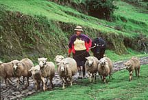
Ecuador Most of the coastal region is lowland at an altitude of less than 300m and there is only a hilly belt, which runs west from Guayaquil to the coast and runs northwards. In the extreme north you find a typical tropical rainforest with two rainy seasons. The time of the rains merge into one as you continue further south, running from December to June. The further south you go the shorter the rainy season becomes and the dryer the country. The southwestern coast near Peru and the Santa Elena Peninsula has little or almost no rainfall. Also vegetation changes from the lush green in the north to thorn and savannah in the south. The shoreline offers long stretches of relatively unspoilt beaches, lined with coconut trees. The cooler and drier central and southern coast regions offer popular beach resort destinations like Mantanita, Punta Blanca, Playas and Puntas Arenas. The beach of Los Frailes in the Machalilla National Park is arguably the most perfect beach on South America's Pacific coast. Ecuador's main agricultural exports come from a small area of lowland to the southeast and north of Guayaquil and from its foot of mountains rising out of the plain. There, between the coastal hills and the Andes, the annual rainfall, temperature and humidity is high, ideal for the growth of tropical crops. In these Guayas lowlands, which get partly flooded, you find bananas, rice, coffee, cocoa and sugar. Guayaquil is Ecuador’s largest city and main port. It is more known as a commercial centre than a vacation spot. |
| Location :
It is located astride the equator on the north-western coast of South
America. The Andean Sierras traverse the country north-south comprising
two major ranges (East and West Cordillera). The highest point is
Chimborazo at 6267m. Climate : Tropical, Varies with altitude, though predominantly hot and humid. Capital Quito (pop. 1.1 million) Population : 11.5 million, 57% in urban areas. Ethnic groups: Indian 25%, Mestizo 55%, Spanish 10%, African 10%. Language : Spanish (Official) |
|
All Rights Reserved @ Travel made
Easy, Udaipur (India)
Email Us